Sunday, November 20, 2011

Raja Ampat Island


The archipelago is located in the remote West Papua. This region save a million beauty beneath the sea. Raja Ampat marine tourism is known as one of the 10 best dive sights in the world. Charm and richness of the underwater world, a mainstay of the island of Raja Ampat through competitive world of tourism in Indonesia and the world through diving tours that can be done in this eastern part of Indonesia.


 The islands are a result of the division of the district of Sorong regency since 2003. District has a population of 31,000 inhabitants including 610 islands with four large islands, namely Pulau Misool, Salawati, Batanta, and Waigeo. Of the 610 islands, only 35 islands are inhabited.With an area of ​​about 46,000 km2, only 6,000 km2 of land, while the remainder is 40 000 km2 of ocean. The islands are unspoiled and beautiful sea is still making a direct tourists hooked.


The archipelago is generally the community of traditional fishermen who live in small villages are located far apart and different islands. They are a friendly community welcoming guests from outside, especially if we bring a gift for them in the form of nuts or candies. This product is a kind of 'peace pipes indian' in Raja Ampat.
Raja Ampat is the Islands District, which has the region's best coral reefs in Indonesia. Marine waters of Raja Ampat mostly covered by corals that have not been disturbed so that it becomes a haven for fish as foraging and breeding.The archipelago consists of a unique miniature environments, ranging from penelukan (embayment) are shaded with a large intake of fresh water, until the broad expanse of coral reef islands (atoll-atoll) tall. In some places like the village Saondarek, when the lowest tides, coral reefs can be seen without the diving and the adaptation itself, these corals can still be alive even though they remained in the open air and exposed to direct sunlight.

One of the best dive sites in the area of ​​Raja Ampat is Kofiau Island. Under the sea, more dazzling panorama.Many international underwater photographers capture the charm of the sea Raja Ampat. Because the area of ​​many islands and narrow straits, then most of the dive at a certain time has strong currents. It allows also to perform a drift dive, dive, following a strong flow of water is very clear with her through the collection of fish.According to Anton Suebu, Manager of The Nature Conservancy Raja Ampat, based on research, in the area of ​​Raja Ampat at least there are more than five hundred species of fish. To preserve the underwater park in Raja Ampat Islands, the government has set Waigeo sea area around the South, which includes the island of Gam, Mansuar Island, Yeben Group and Trunk Group Pele, as a marine wildlife sanctuary covering an area of ​​60 thousand hectares.

To visit this island is not too difficult although it takes considerable time and cost. We can use the airlines from Jakarta to Sorong via Menado for 6 hours of flight. From Sorong, the city is quite large and quite complete facilities for exploring options Raja Ampat there are two, with a boat tour or stay at the resort pinisi Papua Diving. Although most tourists who come to the Raja Ampat today are the divers, the actual location is attractive also for non-diving tourists as it also has white sandy beaches are very beautiful group of islands stunning karst nan and unique flora and fauna.Source : http://capsulx368.blogspot.com/2010/10/wisata-bahari-kepulauan-raja-ampat.html

Wednesday, November 16, 2011

Tiga Warna Lake (Three Colour Lake)


Approximately three-hour trip from the town of Maumere, Sikka regency of East Nusa Tenggara Province (NTT), reached by a rented car through the winding roads, ravines and cliffs, as well as road conditions are not smooth. Was exhausting and challenging, especially the trip made in the early hours. But it all vanished after entering the village of Moni, the village closest to the Lake Flores. Mothers offer Lio woven fabric that is sold at the foot of Mount Flores is the visitor car parking lake. Woven Lio is one of the local potential of local communities that are sold to tourists. Lake Flores colors constantly changing. Changes that could have been caused by mineral content, the influence of biota types of moss and rocks in the crater. For local people that the color change has its own meaning.

Moni village situated in the Village Koanara, District Wolowaru, Ende within 13 miles of Lake Flores. From Moni only takes about 45 minutes to reach the lip of Lake Flores. Promptly at 8:15 pm, after crossing the trail about a mile, we arrived at the mouth of Lake Flores.

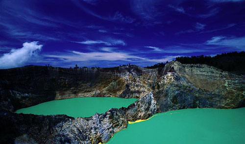
Lake three colors at the top of the crater of Mount Flores who became one of the wonders of this world, really charming with beauty and mystery that are stored on top of the mountain as high as 1690 meters above sea level.
Flores is a combination of the words keli meaning mountain and the quality of the means to boil. Flores is one of the few areas that is very popular tourist destination on the island of Flores, in addition to Komodo, Bena traditional kampong, and the beautiful Marine Park Riung. Volcanic lake is considered magical and mysterious as the third color of the lake is changing, with the passage of time. Earlier this lake is the color of red, white, and blue.
In mid-2006 several changes occurred primarily for two adjacent lakes namely Lake Spirits Youth (Tiwu nua muri ko'o fai) and Spirit Lake soothsayer (Tiwu ata polo). Spirit Lake Youth previously green, in June last year had turned blue. While Lake soothsayer or Evil People who previously dark brown discolored slightly reddish.


A separate lakes, Lake Spirits Parents (Tiwu Ata Mbupu) remain dark green / moss. However, last December when updates visit to the lake Lake Youth Spirits are green again, The Evil Lake to dark blue, and Lake Parents become blackish brown. Lake water color Flores is the mystery of nature.
Morning is the best time to watch the Lake Flores. Shortly before noon, let alone the late afternoon, the lake is usually shrouded in fog that blocked the view. That's why the tourists usually stay in the village of Moni and the new left Kelimutu early days. Flores is located approximately 66 kilometers from the city of Ende and 83 kilometers from the town of Maumere.
From Maumere can use a rental vehicle for travel around Rp 600,000 Maumere-Flores-Maumere. Travel time can be determined and visitors can reach the top of Flores. For a cheaper cost of Maumere can use public bus at a cost of Rp 25,000, but only up to the village of Moni, but it is difficult to get a bus that arrived early morning in the village so that should stay in place. There should also rent a private car or motorcycle taxis to reach the top of the lake.


"If the rental vehicle, visitors can stop at several traditional villages and trips arranged according to agreement. Usually one way to go home, it took eight hours at a price of Rp 600,000. This time is already more than enough including two full hours to enjoy Lake Flores and surrounding areas," said Yanca Paul, the driver who usually rented his personal vehicle.
Apart from Maumere, Flores also can be reached from Ende using intercity bus or rental vehicle, with the price and travel time is relatively not much different.


A cottage of wood is one of the alternative accommodation in the village of Moni before or after visiting Lake Flores. Rates are relatively cheap and attractive natural scenery is a pleasure for tourists with limited funds. Flores is believed to also as a place bersemayamnya human spirits. The lake is visible in the figure is the ghost of the old lake (Tiwu Ata Mbupu) located separately from the other two lakes are huddled together.
To stay in Kampung Moni there are around 20 homestays run by residents with tariff Rp 25,000-Rp 50,000 per night. Government-owned cottage fare of Rp 75,000-Rp 85,000. Flores area surrounded by forest with rare flora found in the area of ​​Flores. There are pine, cypress, redwood and edelweiss. While the existing fauna such as deer, wild boar, pheasant and eagle.
What is seen today is not much different from the situation 15 years ago when updates visit the region. There is little difference, if 15 years ago vehicles visitors can reach the lip of the lake, this time the vehicle can only be arrived at the foot of the mountain and it took 30 minutes walk to the magical lake lip.
Local people believe that the Flores sacred mountain and give fertility to the surrounding nature. In some occasions there is usually a local ceremony and give offerings to the "spirit" that keeps the region.


The third broad lake was approximately 1.051 million square meters with a volume of 1292 million cubic meters of water. Antardanau boundary is a narrow stone wall prone to landslides. The wall has a steep 70-degree angle with a height between 50 to 150 meters.


Kelimutu had erupted in 1886 and left three crater-shaped lake and designated as a national park since February 26, 1992. Flores is also a good place for those who like hiking and enjoying the tropical mountain village region.


Source: liburan.info 

Bromo Mountain


Volcanoes, turn off at once beautiful. An alloy that has attracted tourists to come and explore it. Lonely Planet contains some of the most impressive volcanoes in the world. Apparently, Mount Bromo in Indonesia is one of the list. Here's a list of the volcano.
Mount Hekla, Iceland. Besides called "Gateway to Hell" or entrance to hell. Last bererupsi in 2010.
Hekla means "Hooded one" because the mountain is covered with clouds so as if veiled by clouds. The volcano is erupting pretty much is every 10 years. The mountain is actually comfortable to climb.


Sure feel tired climbing this mountain, but it will pay off when you arrive at the snow-capped mountain peaks. If you are into this mountain in the winter, snowmobile tours there will be upward.
Mount St. Helens, United States. On May 18, 1980, eruption of this volcano bererupsi and creating a crater 1.5 kilometers wide at its northern side. In the vicinity of the mountain, there are a number of tracks for hiking. Climbers who want to the summit must obtain a permit.


Mount Pinatubo, Philippines. After about 600 years is considered as a mountain to die, in 1991, Mount Pinatubo volcanic produced one of the biggest shocks in the 20th century. At that time, he burst the stone dust up to 40 kilometers into the sky and causing it to collapse the head of the mountain almost as high as 300 kilometers.
The new road which can be accessed by pedestrians to climb can be started from Santa Juliana. This place is also a place of pilgrimage every year on 30 November, as a warning of eruption.
Mount Paricutan, Mexico. Paricutan is one of the youngest mountains on earth. When World War II, an eruption occurred in the middle of cornfields. Lava flows up to about 20 square kilometers and hit two villages. Now, the view remains of two villages that the village church tower just visible protruding from the lava that has been frozen.
Trip down the mountain can be done on foot or by horse to ride to the summit. But the views of former lava flow is very intriguing. You can run and jump in the sand mountain.


White Island, New Zealand. White Island has bererupsi constantly over the past three decades. This island can be visited by boat or helicopter from Whakatane. When landing at the Bay Crater, you will see a number of distinctive features of this mountain is very interesting.
Stromboli, Italy. Known as the "Lighthouse of the Mediterranean" as a permanent eruption. Stromboli is a part of the Aeolian Islands, an archipelago of seven volcanic peak which lies off the northern coast of Sicily.
The most remarkable of these islands are Stromboli, bererupsi regularly with dust, steam, and rock. Then the same immediately and dropped into the lava flows to the Mediterranean Sea.
The best place to see Stromboli is on a fishing boat at dusk. To get to the Aeolian Islands can use the ferry from Naples and Milazzo in Sicily.
Soufriare Hills, Montserrat, Caribbean. Soufriare Hills again after over 4 centuries bererupsi ie in 1995. After returning calm over the next decade, in January 2007, this volcano erupted again, and clouds of ash blanketed the island. If you want to the island, there is the observatory is open to visitors.
Hawaii Volcanoes National Park, United States. Hawaii Volcanoes National Park has two active volcanoes. In the midst of scenery of the crater and cinder cones, high hills with rocks, sea of ​​lava has hardened. You can pay to watch the lava flow.
Rabaul, Papua New Guinea. In 1994, twin volcanoes around Rabaul erupted and the many tourists who consider it the largest eruption in the Pacific. The eruption destroyed the airport and covered most of the city with a thick rain of ash.
The last eruption has led to the relocation of the provincial capital of Kokopo. If you want to visit there, tourists can sail which are held twice a week from Rabaul to Lae.
Mount Bromo, Indonesia. During the 20th century, this mountain has erupted 3 times at regular intervals with the largest eruption occurred in 1974 and the last eruption occurred in this year, 2011.
You can hire a horse or jeep ride to cross the sea of ​​sand toward the top of Bromo and Bromo. Amid the sea of ​​sand Bromo large temple there with a typical Javanese architecture that cater for the local Hindu temple.


Souce: travel.kompas.com

 
Design by Wordpress Theme | Bloggerized by Free Blogger Templates | JCPenney Coupons